|
The History Center has more than one thousand maps of Austin and Travis County from the mid-1800s to the present. These maps illustrate the City's changing size and shape over the years and offer invaluable clues to structures and landmarks long since gone from our landscape.
Maps in the collection include:
- Bird's-eye view maps
- Sanborn Fire Insurance maps from 1885 to the 1970s
Some Sanborn maps are available from the library's Online Database page. The
Digital Sanborn Maps database is available thru the TexShare program, and you need to have an Austin Public Library card to access this from your home computer.
- Aerial photographs from the 1940s to 1989
- Travis County Highway Maps
(Texas County Highway Maps are available online, for some years, from the University of Texas)
- Plats, abstract maps, and neighborhood plats
- Cemetery maps
- Austin Street maps
- City of Austin Use maps
- Topographic and geologic maps of Austin and Travis County
The Perry-Castañeda Library at the University of Texas has a number of Austin area maps available on-line, in its Maps Collection.
|
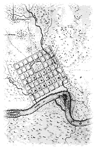
Detail from 1839 map.
Map L-2 |